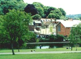
Looking from Lowndes Park across Skottowes Pond to the new Town Hall and High Street beyond. St. Mary's Way, the main North-South through road lies hidden between the pond and the Town Hall.
|
Town Layout
The town was badly served by local government and planners during the expansion that followed the arrival of the railway at the turn of the century. Instead of making provision for a second North-South route through the town and parallel to the High Street, "Newtown" was created as effectively a ribbon development, extending the High Street to the North. St Mary's Way was built to relieve the pressure in the early 1920s. The High Street became more and more of a problem as traffic volumes increased. A particularly hazardous corner at the old Red Lion Pub in Market Square was re-engineered in 1937 and the pub itself rebuilt. The High Street was made into a one-way South and North bound traffic was routed along St Mary's Way next to Skottowes Pond. Finally around 1990, all regular traffic was removed from the High Street and St. Mary's Way was re-designed to take both directions of traffic. Currently the High Street is open to delivery vehicles although the Town Council is working towards restricting such access with what approximates, in Local Government terms, to zeal. Traffic flow through the town remains a problem particularly as the A416 is the first available North-South rat-run outside the M25. Things can only get worse as the M25 becomes more congested. The proposed buslanes on the M25 will perhaps break the camels back. Much could be done to improve traffic flow through the town although the political will to do this is, quite simply, not there.
|